Hike through "Trou à l'Ours" (Bear's Hole) in Valley of Nant
ツアー: ナン谷の「トゥルー・ア・ラ・ウルス(熊の穴)」へ(2020年6月20日)
ツアー案内・Hike overview- 距離・length: 9.55 km
- 登り、下り・ascents/descents: 652 m / 681 m
- 歩く時間・hiking time: 3 h 45 m
- スタート地点・starting point: B&B "La Tsalounâ", Les-Plans-sur-Bex (1,100 m)
- 経由地・intermediate points: Cinglo (1,600 m), Trou à l'Ours (1,660 m), Pont de Nant (1,252 m)
- ゴール地点・end point: (1,100 m)
- そのほか・remarks:
白・赤・白表示で山登山道として指定されており、殆どの道があまり難しくないが、鎖の助けを借りて下りる狭い穴も道の一部だから、見くびってはいけない。バックパックを背負うには狭すぎて、バックパックと別々に下りる必要がある。あるハイカーは、犬が穴を登ることを拒否したため、引き返すことしかなかった。犬を連れて歩くコースではない。
The path is easy enough and designated red-white as mountain hiking path, but it does involve a short climb (3 meters) down a narrow hole with help of a chain. It's too narrow for backpacks, you and your backpack will have to go down separately. We saw one hiker having to turn back because his dog categorically refused to climb the hole; this tour probably is not for you if you want to hike with a dog. - ツアーマップ・LINK TO HIKING MAP
ツアーの前夜、レ・プラン・シュル・ベックス村(Les-Plans-sur-Bex)の魅力的なB&B 「ラ・ツァルーナ」に泊まり、ここから出発した。ポン・ド・ナン(Pont-de-Nant)まで30分、そこからかなり急な小道を登っていくと、一時間後にシンクロという古い狩猟小屋にたどり着く。現在は自然保護区域になっているので、狩猟は禁止されている。狩猟小屋の奥にあるトイレをみてください。とっても素朴な感じ! ここから15分以内に「トゥルー・ア・ラ・ウルス(熊の穴)」に到着。その穴を形成している岩の上には様々な人が座っていて、ランチを食べながら、ナン谷を見渡していた。土の中を真っ直ぐ下を指す道標を見たら、思わず笑ってしまった。直ぐ下を指す道標を滅多に見えないだろう。トゥルー・ア・ラ・ウルスを経て、さらに30分ほどで谷底に到着。ナン谷は息を呑むような美しさで、珍しい種類の花が咲き乱れ、童話を思わせるような美しさだ。ポン・ド・ナンのレストランの近くには、スイス最古の高山植物園の一つであるラ・トーマシアがある。ポン・ド・ナンまでは車で行くことができるが、公共交通機関を利用する人はレ・プラン・シュル・ベックスまで戻り、そこからバスに乗る(事前にバスのスケジュールを確認しておきましょう)。
The night before our hike we stayed at the charming B&B "La Tsalounâ" in Les-Plans-sur-Bex and started from here. It's a half hour up to Pont-de-Nant, and from there up a pretty steep trail that leads to the old hunting lodge Ciclo (it's a nature protection area now, so hunting is no longer allowed). Check out the toilet in the back, it's very rustic! From here you'll reach the Trou à l'Ours, the "bear's hole" soon. Various people sat on top of the rocks that form the hole, enjoying lunch and a grand view across Valley of Nant. From here the path leads straight down. I got a laugh out of the way sign pointing straight down into the earth. There are not many opportunities to see a sigh like that! After passing through Trou à l'Ours, we reached the valley floor in another 30 minutes. Valley of Nant is breathtakingly beautiful, with a rare variety of flowers, that will remind you of fairy tales. One of Switzerland's oldest alpine gardens, La Thomasia, is situated close to the restaurant of Pont-de-Nant. You'll pass it on the way back. You can reach Pont-de-Nant by car, but people who depend on public transport need to return to Les-Plans-sur-Bex and catch the bus there (make sure to the check the schedule beforehand).
The night before our hike we stayed at the charming B&B "La Tsalounâ" in Les-Plans-sur-Bex and started from here. It's a half hour up to Pont-de-Nant, and from there up a pretty steep trail that leads to the old hunting lodge Ciclo (it's a nature protection area now, so hunting is no longer allowed). Check out the toilet in the back, it's very rustic! From here you'll reach the Trou à l'Ours, the "bear's hole" soon. Various people sat on top of the rocks that form the hole, enjoying lunch and a grand view across Valley of Nant. From here the path leads straight down. I got a laugh out of the way sign pointing straight down into the earth. There are not many opportunities to see a sigh like that! After passing through Trou à l'Ours, we reached the valley floor in another 30 minutes. Valley of Nant is breathtakingly beautiful, with a rare variety of flowers, that will remind you of fairy tales. One of Switzerland's oldest alpine gardens, La Thomasia, is situated close to the restaurant of Pont-de-Nant. You'll pass it on the way back. You can reach Pont-de-Nant by car, but people who depend on public transport need to return to Les-Plans-sur-Bex and catch the bus there (make sure to the check the schedule beforehand).
 |
| Les-Plans-sur-Bex(標高1,100m)にある魅力的なB&B 「ラ・ツァルーナ 」から出発する We pass the night at the charming B&B "La Tsalounâ" in Les-Plans-sur-Bex (1,100 m) and head out from here |
 |
| シンクロという古い狩猟小屋(標高1,600m)を通って、トゥルー・ア・ラ・ウルス(標高1,660m)に向かう Having passed the old hunting lodge Cynclo (1,600 m) 10 minutes back, we head towards Trou à l'Ours (1,660 m) |
 |
| トゥルー・ア・ラ・ウルス(標高1,660m)の上から見たナン谷の印象的な景色(標高1,660 m) Impressive view of the Valley of Nan from on top of Trou à l'Ours (1,660 m) |
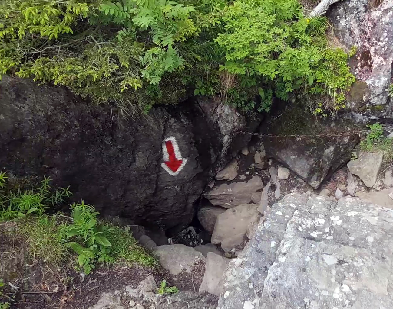 |
| ここからはトゥルー・ア・ラ・ウルス(標高1,660m)をまっすぐ下っていく From here the path leads straight down the Trou à l'Ours (1,660 m) |
 |
| 四つん這いになって背中も使ってトゥルー・ア・ラ・ウルス(標高1,660m)を下る Climbing down Trou à l'Ours (1,660 m) using all fours, plus the back and behind |
 |
| 下から見たトゥルー・ア・ラ・ウルス(標高1,660m)。暗いところは穴の中を通るところだ Trou à l'Ours (1,660 m) seen from below (where it's dark is where you'll pass through the hole) |
 |
| 谷底に向かって下っていく Heading down towards the the valley floor |
 |
| ナンの谷の奥(標高1,470 m)に到達 Reaching the back of Valley of Nan (1,470 m) |
 |
| 川や周辺の山々の景色を楽しみながら一休みする Taking a break and enjoying the views of the river and the surrounding mountains |
 |
| ポン・ド・ナン(標高1,252m)に戻る道は自然のネイチャーロードだ The path down to Pont de Nan (1,252 m) is a nature road |


コメント
コメントを投稿